
CONEXRA

Together Growing Your Business
to The Best Performance


We specialize in providing professional services in reality capturing, lidar scanning and Scan to BIM. Our expertise ensures that you receive the highest quality data and models, enabling your projects to achieve unparalleled accuracy and efficiency.
Our Services
Matterport


Matterport is a powerful 3D capture platform that transforms physical spaces into digital twins. Capturing a standard 2000 sq ft commercial space takes about 1.5 to 2.5 hours. After capturing, the data is uploaded to the Matterport cloud via the Capture app or directly from the camera. The cloud software then processes the data, creating a detailed 3D model by stitching images and aligning scans. Users can navigate the 3D space, view dollhouse models, floor plans, and take guided tours, enhancing their experience with interactive features.
Our Services Using Matterport

3D Virtual Tours
Create immersive 3D virtual tours of physical spaces, enabling clients to explore properties remotely. This saves time and resources for buyers, tenants, and agents.

Real Estate Marketing
Enhance property listings with 3D tours, floor plans, and high-res photos to boost engagement. This leads to faster sales and rentals.
Construction Documentation

Capture detailed 3D models of construction sites at various project stages to aid progress tracking and quality control. This enhances communication among stakeholders.
Facility Management
Create accurate 3D models of facilities for maintenance, space planning, and asset management. This improves operational efficiency and provides a digital twin of the property.


Architecture and Design
Use 3D models for space planning, design validation, and client presentations. This allows for precise measurements and better visualization of design concepts.
Virtual Staging
Add virtual furniture and decor to empty spaces in 3D models, helping buyers visualize a space's potential without physical staging.


Historical Preservation
Digitally preserve and archive historical sites and artifacts to ensure the preservation of cultural heritage in a digital format.
RTC 360 Lidar Scanning

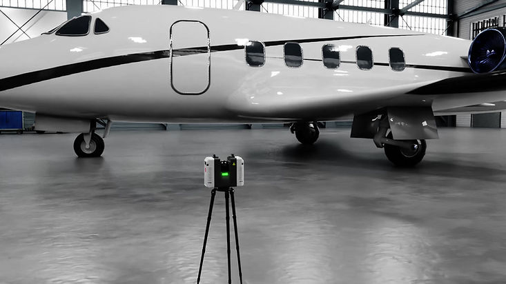
Using the RTC360, we achieve high-speed data capture of 3D point clouds at up to 2 million points per second, conducting up to 180 stations per day with 3-meter intervals for efficient data collection. Seamless integration with Leica Geosystems software like Cyclone and CloudWorx ensures smooth workflow from capture to final deliverable. Automatic field registration and real-time quality monitoring via a connected tablet enable immediate adjustments, ensuring high-accuracy point cloud registration within a day. The scanner's portability and intuitive interface on a tablet make it accessible for users of all skill levels to operate efficiently.
Our Services Using RTC 360

Virtual Reality and Simulation
Create immersive VR environments and simulations using 3D scan data to enhance training, planning, and presentations with realistic virtual experiences.

As-Built Documentation
Create precise as-built documentation for buildings, infrastructure, and industrial facilities. This ensures accurate records of existing conditions for renovation, retrofitting, and maintenance projects.

Construction Monitoring
Track construction progress with regular scans and
compare them to design models. This helps identify deviations, monitor progress and ensure adherence to project timelines and specifications.
Facility Management

Create accurate 3D models of facilities for maintenance, space planning, and asset management. This improves operational efficiency and planning by providing a digital twin of the property.

BIM Integration and Design
Integrate point cloud data into Building Information Models (BIM) to enhance accuracy and provide a reliable foundation for design, construction, and facility management.

Topographic and Land Surveys
Perform detailed topographic and land surveys for site planning and analysis. This provides accurate terrain models and topographic maps for civil engineering, urban planning, and landscape design.

Heritage and Archaeological Documentation
Digitally preserve and document historical sites and archaeological findings to ensure accurate, detailed recording of cultural heritage for research, restoration, and preservation.
BLK 360


At Conexra, we utilize the BLK360's advanced HDR imaging and ultra-fast scanning capabilities to capture high-quality photospheres and point clouds at 680,000 points per second. We ensure quick and stable data transfers via USB-C, up to nine times faster than the BLK360 G1. Our seamless integration with Reality Cloud Studio allows us to share, visualize, and utilize digital reality data directly in the cloud, enhancing collaboration and maximizing the potential of reality capture data.
Our Services Using BLK 360

Virtual Reality and Simulation
Create immersive VR environments and simulations using 3D scan data, enhancing training, planning, and presentations with realistic virtual experiences.

As-Built Documentation
Create immersive VR environments and simulations using 3D scan data, enhancing training, planning, and presentations with realistic virtual experiences.

Construction Monitoring
Monitor and document construction progress with regular 3D scans, ensuring projects adhere to plans, timelines, and quality standards while identifying deviations early.

Facility Management
Capture detailed 3D scans of industrial plants and facilities for maintenance, modifications, and safety inspections, improving operational efficiency, planning, and safety through accurate modeling of complex environments.

BIM Integration and Design
Integrate point cloud data into Building Information Models (BIM) to enhance accuracy and provide a reliable foundation for design, construction, and facility management.

Real Estate Marketing
Create 3D virtual tours and high-quality images of properties to enhance listings, increase engagement, and enable remote visualization for potential buyers.

Heritage and Archaeological Documentation
Digitally preserve and document historical sites and archaeological findings, ensuring accurate and detailed recording for research, restoration, and preservation of cultural heritage.
DJI RTK 350 L2 P1 Reality Capture and Photogrammetry


Using DJI RTK L2 LiDAR, we offer two scanning modes: repetitive for high-precision mapping and non-repetitive for deeper structural analysis. Smaller laser spots enable detailed, high-resolution point clouds, capturing fine surface features. High-frequency laser pulses and advanced processing ensure fast and efficient mapping, ideal for diverse applications. Post-flight, we process raw data into detailed and actionable outputs, leveraging the system's capabilities for high-quality results.
Our Services Using DJI RTK 350 L2 P1
Topographic Mapping and Land Surveying

Digitally preserve and archive historical sites and artifacts to ensure the preservation of cultural heritage in a digital format.
Construction Site Monitoring

Construction site monitoring tracks progress, calculates volumes, and manages logistics. This enhances project management and ensures adherence to schedules and plans.
Urban Planning and Development

Urban planning and development capture accurate data for zoning and infrastructure. This helps planners make informed decisions and optimize urban growth.
Infrastructure Inspection

Infrastructure inspection precisely assesses bridges, roads, and power lines. This enhances safety, identifies issues early, and aids maintenance planning.
Forestry and Vegetation Analysis

Forestry and vegetation analysis assess forest structure, canopy height, and vegetation health. This aids in forestry management, biomass estimation, and environmental monitoring.
Mining and Quarrying
Mining and quarrying capture detailed 3D data for volume measurements and monitoring. This improves operational efficiency, safety, and resource management.

Heritage and Archaeological Documentation
Heritage and archaeological documentation create detailed 3D models of sites. This preserves cultural heritage and supports research and analysis.
